Lake Tillery
Badin Lake
Rocky River
Pee Dee River
Falls Reservoir
Lake Tillery
Badin Lake
Lake facts:
Lake Tillery is more than 5,000 acres with 104 miles of shoreline. A maximum depth of 70 feet and water fluctuations are minor.
Recreation:
Swimming, boating, boat rentals, fishing, water sports. The fishing and boating are great! Numerous, attractive lake front housing communities provide residents with year-round enjoyment of this popular destination.
Lake facts:
The reservoir covers an area of 5,350 acres with 115 miles of shoreline, and a maximum depth of 200 feet. Water fluctuations are minor.
Recreation:
Swimming area, public beaches, boating, water sports, picnic areas, and fishing.
The Mystery of the World War II B-25 and Badin Lake
A World War II B-25 bomber and the bodies of its pilot and co-pilot have rested at the bottom of Badin Lake in Stanly County for more than 70 years. The stories and conspiracy theories surrounding the crash and the fact that the wreckage and bodies were never recovered have made the lake a popular spot for history buffs.

Rocky River
Pee Dee River
The Rocky River is part of the Yadkin Pee Dee River Basin, and the river forms the boundary between Cabarrus, Stanly, Union and Anson Counties. The Rocky River’s headwaters begin in southern Iredell county and terminate at the confluence with Yadkin Pee Dee at Fork Farms (Catawba Lands Conservancy has a conservation easement on this property) in Stanly County. It is unconfirmed but believed that the Rocky River is the longest undammed river in North Carolina. The Rocky River Blueway of the Carolina Thread Trail network is approximately 49 miles in length where paddlers can experience varying degrees of difficulty depending on the amount of precipitation.
On this stretch of blueway, you will experience what the Piedmont floodplain forest habitat has to offer a paddler visiting upclose. Over 50 species of birds call this area home, including some imperiled species within the region. Birders will enjoy the opportunity to see prairie warbler, Prothonotary warbler, red-headed woodpecker, great blue heron, eastern meadowlark, pileated woodpecker, and kingfisher. Paddlers may also hear the calls of the Cope’s gray tree frogs, cricket frogs, spring peepers and upland chorus frogs or see over 10 species of butterflies like the Carolina satyr. The shoreline is trimmed with numerous floodplain trees, including the bitternut hickory, sourwood, cottonwood, swamp chestnut oak, and the black walnut.
This portion of the Rocky River is also very close to the Little Meadow Creek. This is historically relevant as the Little Meadow Creek was the site of the America’s first Gold Rush

The Pee Dee River, also known as the Great Pee Dee River originates in the Appalachian Mountains in North Carolina, where its upper course, above the mouth of the Uwharrie River is known as the Yadkin River. It is extensively dammed for flood control and hydroelectric power. The lower part of the river is named Pee Dee after the Native American Pee Dee tribe. The Pee Dee region of South Carolina, composed of the northeastern counties of the state, was named after the tribe and/or river. The first Europeans believed to have navigated part of the river was a party sent by Lucas Vázquez de Ayllón in 1521. They named it “River of St. John the Baptist.”
The river was an important trade route through the Low Country from colonial times. The largest lumber company in the world existed at the turn of the 20th century near the river’s mouth at Georgetown. The virgin pine forests of the Pee Dee region were cut over, and the logs floated in rafts downriver to be sawn into lumber and exported to the northern United States and Europe.
The lower part of the river flood plain was extensively developed for rice culture in colonial time; rice was the major export of the area from the port at Georgetown. Rice culture declined with the loss of slave labor after the Civil War, and increased overseas competition. Two hurricanes at the beginning of the 20th century destroyed much of the rice canal infrastructure and effectively ended the remnants of rice culture.
Today the river is not extensively used for navigation. It is an important source of electric power and public water supplies, as well as recreational use. While the Pee Dee is free-flowing in South Carolina, upstream in North Carolina, several dams have been constructed on it. The opening and closing of these dams causes dramatic swings in the depth of the river in South Carolina. The sharing of water between the two states has sometimes been a matter of controversy, particularly during period of drought. Some commercial fishing is done during the winter shad run, and for shrimp in the lower reaches. The river is excellent for recreational fishing and boating. There are numerous boat landings, yet most of the river is wild, with forests of tupelo, oak and gum along its shores. Herons and alligators can be seen along the way, and a lucky sighting of a bald eagle is possible.
The lower part of the river from Highway 378 to Winyah Bay has been designated a Scenic River.

Falls Reservoir
Falls Reservoir is the lake created between Narrows Dam, holding back Badin Lake, and Falls Dam which marks the beginning of Lake Tillery. The lake itself is about 2 miles in length and fairly narrow. On a map it looks like nothing more than a part of the Yadkin River. To be sure, this is a little known treasure of central North Carolina. While the lakes of the Yadkin River are generally surrounded by housing developments and golf courses, Falls is not.
There are only two access points to the lake, one on each side of the southern end of the lake. The access near Badin in the only one that is paved and has a boat ramp suitable for powerboats. This, combined with the lack of knowledge of the lake, keep traffic down to a minimum. Even on busy weekends there are few visitors to Falls Reservoir.
The scenery at Falls is unmatched in the area and one will likely witness the fishing of Bald Eagles. The shores of the lake are filled with exposed rock formations. A few of the formations are suitable for cliff jumping and repelling, though it is not recommended without prior knowledge of the proper cliffs. There are even waterfalls to explore along the western shore.
You can also paddle up to the base of Narrows Dam and picnic on the rocks below the spillway. It is hard to describe the beauty of this lake in comparison to the other Yadkin River lakes, it is completely unique and breathtaking.
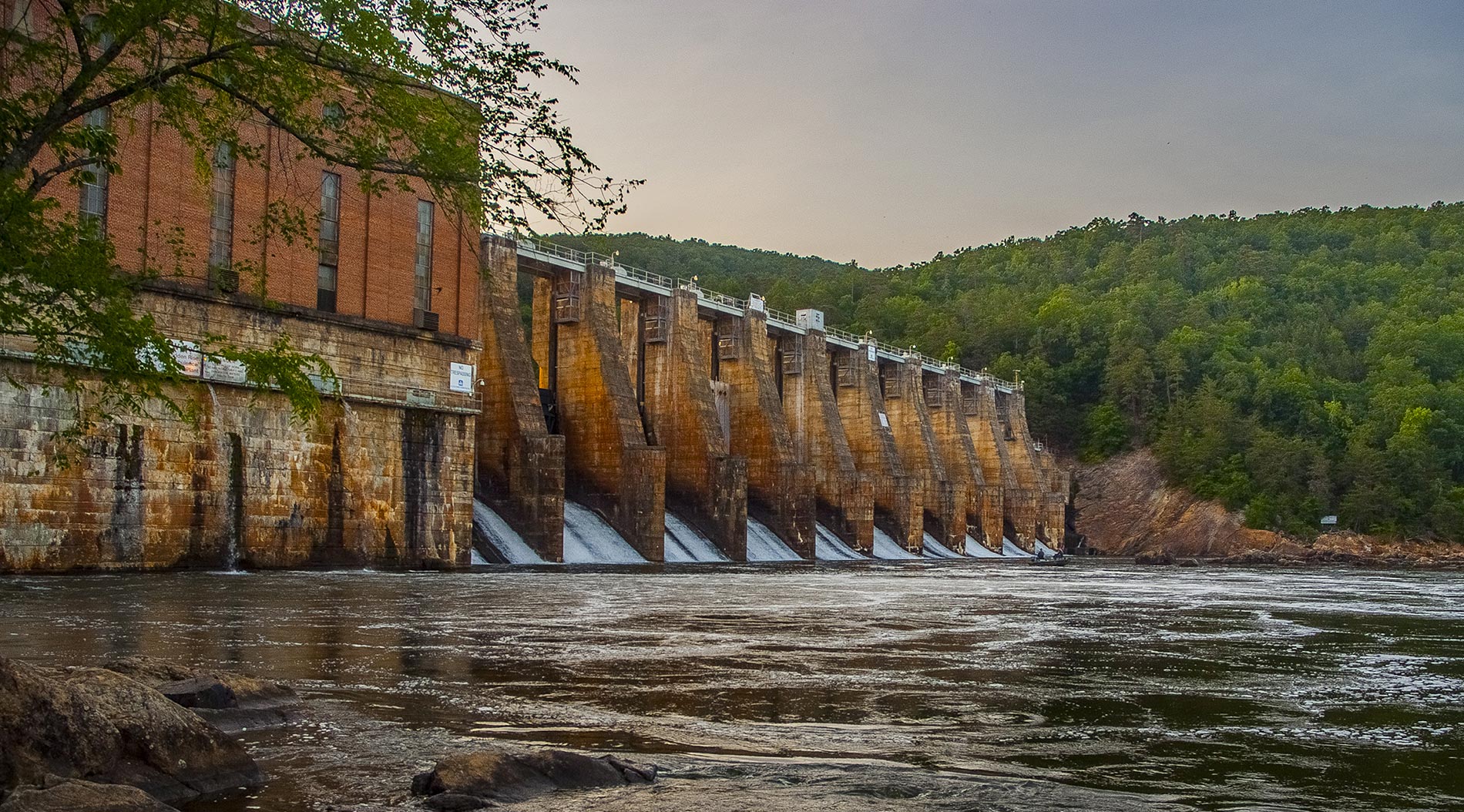
Interestingly, Falls Reservoir rests atop what was once known as the “Narrows of the Yadkin” which was a notoriously rough section of the river. It has been rumored that it held some of the best whitewater in NC. One can only imagine what beauty the river held before the power was harnessed for electricity. In 1917, Narrows Dam was completed forming Badin Lake and later (I can’t remember the date) Falls Dam was completed thus creating Falls Reservoir.
Because this lake was formed by flooding a mountainous area the lake is extremely deep in places. Most of the eastern shore is a virtual drop-off from dry land. The pool directly below the spillway is reported to be up to 200 feet deep due to erosion from high volume releases.
The land to the east of Falls is Uwharrie National Forest aside from the shoreline near Narrow’s Dam. There are several campsites scattered along the shores that are obvious and established. The western shore is all private land.
It may seem strange or unlikely that a place like this exists in central NC but it is absolutely true. It is shocking even to some locals that the lake even exists and it is a trip worth taking. There is easily enough to explore for a day trip and even an overnight trip could be rewarding.
View Stanly County Lakes in a larger map
Lake Rentals
Tillery Boat Rentals
1183 Lilly’s Bridge Rd, Mount Gilead, North Carolina
844-845-5379
River Daisy
704-985-6002
River Rooster Kayak Rentals
1127 North Main Street Oakboro, NC 28129
704-781-7454
